

July 15, 2022
Esri Melds GIS with AI, Graph, and Analytics
(Image courtesy Esri)
Esri has long been the industry leader in geographic information systems (GIS), which are used by urban planners, building engineers, and landscape designers around the world. At its UC 2022 conference this week, the company showed how its moving ArcGIS in the direction of big data with advances in analytics, AI, and even graph databases.
Spatial analysis of big data has been a research effort at Esri for years, Esri founder and president Jack Dangermond said during his keynote address on July 11. The new GeoAnalytics Engine that Esri officially unveiled last month is a result of that effort.
“There are these big data lakes and data warehouses that live in cloud, like Azure and AWS, and they’re just massive in size,” Dangermond said. “They’re so big you can’t take the data out and put it into a GIS. So what’s been invented here is a software library of about 100 tools that you can send to wherever these big data reservoirs are, and it performs spatial analysis on them, and you can use the results in ArcGIS.”
The idea behind ArcGIS GeoAnalytics Engine is to integrate geospatial analytics directly into data scientists’ big data workflows. Data scientists working in a traditional big data environments typically lack the capabilities needed to analyze geospatial data in an easy manner. It can be done, but the environments typically aren’t set up to make it simple, according to Esri.
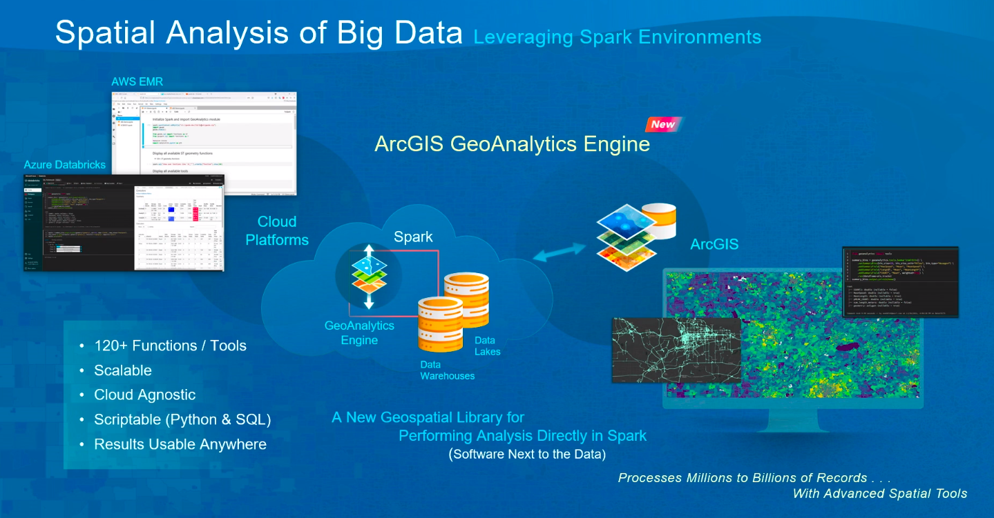
Esri’s new ArcGIS GeoAnalytics Engine brings geospatial analysis to traditional data science workflows
Esri hopes to change that with the new GeoAnaltyics Engine, which leverages Apache Spark as a data processing engine. The new offering can either bring ArcGIS capabilities to an existing Spark environment, such as Amazon EMR, Azure via Databricks, or Google Cloud Dataproc. Alternatively, it can bring Spark-based data processing directly into ArcGIS running in a customer’s site.
According to the ArcGIS GeoAnalytics Engine web page, the new offering includes 120 geoanalytics tools and functions deigned to help users understand trends, patterns, and correlations in their data.
“Find hot spots and point clusters, perform geographically weighted regressions, detect incidents, find dwell locations, reconstruct tracks, trace proximity events, calculate motion statistics, and more,” the company says. The software works up to 100 times faster than open source analytical GIS offerings, Esri claims.
“The combined power of the Amazon EMR big data platform and Esri’s ArcGIS GeoAnalytics Engine allows our customers, regardless of spatial expertise, to seamlessly leverage ArcGIS GeoAnalytics Engine spatial tools and functions in their big data analysis and models,” said Abhishek Ram, AWS’s head of products, worldwide public sector.
During his keynote, Dangermond also talked about a new initiative to integrate machine learning and AI technologies and techniques into the world of geospatial analysis. The company has grouped these efforts into its GeoAI Hub.

Esri president Jack Dangermond addressed the crowd during his July 11, 2022 keynote at UC 2022 in San Diego, CA.
The first offering in the GeoAI Hub is object detection. The software utilizes deep learning techniques to automatically find objects in GIS data, such as aerial surveillance data. It can be used to spot things like buildings, swimming pools, and oil and gas mines. It can also detect roads, how full parking lots are, and the traffic density on roads. Up next will be “pixel-wise classification for raster inputs,” which will be useful for automatically determining things like groundcover details from aerial imagery.
“We have an amazing team integration AI, machine learning, and deep learning right into ArcGIS,” Dangermond said. “This is a technology that’s really revolution in IT and our society today. We call it Geo AI but we’re also integrating with open science libraries with Python so we can enrich what users do in image analytics and being able to extract from text geographic entities, or use machine learning to look at geospatial data, vector data, and tabular data.”
“It’s quite intriguing because it’s automating our work, giving us the opportunity to discover new things and new pattern and relationship across the platform,” he continued.
Esri is also making headway in another exciting area of big data analytics: Graph databases and graph analytics. Esri is launching a new product called ArcGIS Knowledge that incorporates graph analytics. It’s available for ArcGIS Pro and Enterprise customers.
“Graph analytics are a whole world of looking at entities and relationships between them, not necessarily spatial,” Dangermond said. “So we’ve been investing in taking this body of knowledge–how people are related and how supply chains work and so on–and bringing it right into the GIS frame. This is going to be profound because it allows us to not only look at relationships that are not necessary spatial, but see them in spatial terms.”
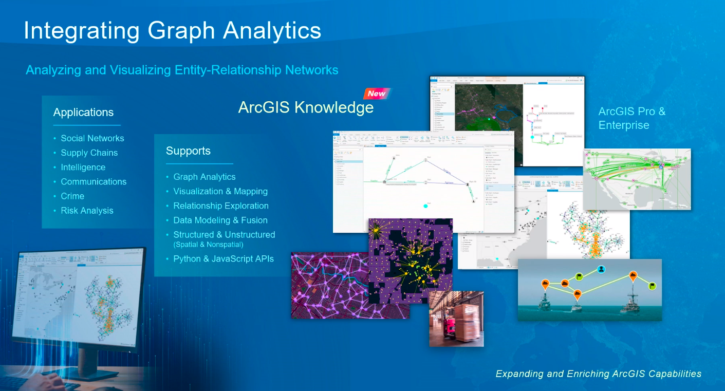
Esri is bringing graph analytics into ArcGIS with a new product called ArcGIS Knowledge
ArcGIS Insights has also been enhanced to provide better analytics functionality on geospatial data. The software, which is separate from ArcGIS, helps users to explore, visualize, and analyize their data using a variety ofcapabilites.
ArcGIS Insights is about visualizaing all types of enterprise data, Dangermond said. “I can pull from [data sets] dynamically and visualiaze them in this dashboard-like plane,” he said. “And I can buld these beautiful information products and then send it to somebody else–not as a paper producdt, but as a digital product, so somebody else can start playing with exactly the same data and see interesting pattern and relationships.”
In addition to geospatial tools, the available pool of geospatial data is growing quickly, and Esri is working to keep ArcGIS customers on the leading edge of it. To that end, Dangermond talked about a couple of other efforts underway at the Redlands, California company.
For starters, it has released an ArcGIS Maps SDK that plugs into popular gaming engines, such as Unity and Unreal. No, Esri isn’t going into the gaming world. But it is giving developers more tools for incorporating the level of immersive realism into digital 3D mockups of our world.
“Your kids are probably playing some of derivative game on these things, but they’re not doing it on real geography,” Dangermond said. “What this means is plugging in your data sets into a game engine and having a virtual reality experience. Lots of practical application here. This will be developed by game engine developer and open up new opportunities for you to leverage your information.”
Esri is also working with Autodesk to enable their respective customers to mesh CAD drawings with GIS data. Dangermond said the integration of BIM [building information models] and GIS together will allow users to instantly pull up detailed engineering or building information from a map. “This is going to change the way that engineers and planners and landscape people collaborate and work together,” he said.
UC 2022 ends today. For more info, check out the website.
Related Items:
Esri Puts Federal Climate Change Action on the Map
Esri Simplifies Developer Access to Location Data with ArcGIS Platform
For Esri, Analytics All About Location, Location, Location
Vendors:
Esri
Leading Solution Providers


Tabor Network
Sponsored Multimedia


Featured Events
-
AI & Big Data Expo North America 2024
 June 5 - June 6Santa Clara CA United States
 -
CDAO Canada Public Sector 2024
 June 18 - June 19
 -
AI Hardware & Edge AI Summit Europe
 June 18 - June 19London United Kingdom
 -
AI Hardware & Edge AI Summit 2024
 September 10 - September 12San Jose CA United States
 -
CDAO Government 2024
 September 18 - September 19Washington DC United States