

April 19, 2021
Novel Use of 3D Geoinformation to Identify Urban Farming Sites
April 19, 2021 — Urban farming has picked up in scale and sophistication globally in recent years. Several innovative urban farming approaches have been introduced in Singapore, such as rooftop farming, optimisation of land use, the introduction of more greenery into the built environment, and the 30 by 30 vision set by the Singapore Food Agency to target the production of 30 per cent of Singapore’s nutritional needs by 2030.
However, the suitability of specific crops and locations for farming is variable, and conventional methods to assess farming potential involve field visits and time-consuming measurements.
How can we assess the suitability of farming locations in land scarce Singapore quickly and accurately?
Predicting sunlight conditions to determine farming sites and suitable crops

Dr Filip Biljecki showcasing the urban digital twin used in the study.
Led by Dr Filip Biljecki, presidential young professor at NUS Design and Environment, the study investigates the possibility of using three-dimensional (3D) city models and urban digital twins to assess the suitability of farming locations in high-rise buildings in terms of sunlight availability.
Titled “3D city models for urban farming site identification in buildings”, their research paper was published in the journal Computers, Environment and Urban Systems, based on a proof of concept focused on a residential building situated at Jurong West in Singapore. Field surveys were carried out to validate the simulation figures.
“We investigate whether vertical spaces of buildings comprising outdoor corridors, façades and windows receive sufficient photosynthetically active radiation (PAR) for growing food crops and do so at a high resolution, obtaining insights for hundreds of locations in a particular building,” shared the paper’s first author Mr Ankit Palliwal, who graduated from the NUS Geography with a Master of Science in Applied GIS.
PAR is defined as the portion of solar spectrum in the 400 to 700 nm wavelength range, which is utilised by plants for photosynthesis. Its amount is a key factor to understand whether a location has the potential for farming and what kind of crops can be grown at a specific site because different crops require different PAR conditions for its optimal growth.
“We conducted field measurements to verify the veracity of the simulations and concluded that 3D city models are a viable instrument for calculating the potential of spaces in buildings for urban farming, potentially replacing field surveys and doing so more efficiently. We were able to understand the farming conditions for each locality in a specific building without visiting it, and to decide which crops are suitable to be grown. For this particular building, we have identified locations that would be suitable for growing lettuce and sweet pepper. This research is the first instance in which 3D geoinformation has been used for this purpose, thus, we invented a new application of such data, which is becoming increasingly important in the context of smart cities,” shared Dr Biljecki, the principal investigator of the study.
Potential to upscale and cover entire cities
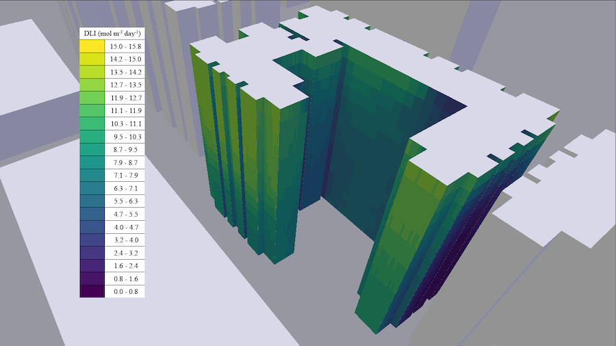
One of the results of the simulations, providing insight for decision-making for high-rise urban farming and for maximising the crop yield.
3D spatial data has an unparalleled advantage over doing field measurements when there are many locations to evaluate and especially when scaling up the estimations at the precinct or urban scale.
Such analyses can be conducted using 3D models obtained from open data, and the simulations can be run using open-source software, facilitating replication elsewhere and scalability to cover entire cities, uncovering their urban farming potential and aid in devising planning strategies.
“Another possible work direction would be to investigate if 3D city models can be combined with existing approaches to assess the suitability for installing solar panels and energy simulations, recommending the optimal mix and arrangement of photovoltaic installations and agricultural crops in the same building, presenting a holistic solution for supporting green buildings and sustainable development. Given the dynamic features of urban farming, and accompanying aspects such as real estate and microclimate factors, this work brings a new dimension to digital twin developments,” concluded Dr Biljecki.
The study is a research project under the Urban Analytics Lab, a multidisciplinary research group formed in 2019 which focuses on urban data science, 3D GIS, and digital twins. The research team for this study is led by Dr Filip Biljecki and comprises Mr Ankit Palliwal, as well as PhD candidate Ms Song Shuang and Assoc Prof Hugh Tan Tiang Wah from the NUS Biological Sciences.
Source: National University of Singapore
Leading Solution Providers


Tabor Network
Sponsored Multimedia


Featured Events
-
AI & Big Data Expo North America 2024
 June 5 - June 6Santa Clara CA United States
 -
CDAO Canada Public Sector 2024
 June 18 - June 19
 -
AI Hardware & Edge AI Summit Europe
 June 18 - June 19London United Kingdom
 -
AI Hardware & Edge AI Summit 2024
 September 10 - September 12San Jose CA United States
 -
CDAO Government 2024
 September 18 - September 19Washington DC United States