

October 27, 2020
Deep Learning Clears the Skies for Volcano Monitoring
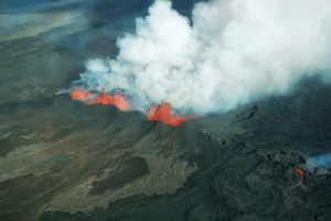
Major volcanic eruptions are rare, but potentially cataclysmic: in 2018 alone, a pair of volcanic eruptions in Guatemala and Indonesia killed at least 600 people. As in earthquake sensing, the underlying signals that define volcanic activity are noisy due to instrumental interference, and prophesying volcanic eruptions is an imprecise (and less-than-actionable) affair. Researchers from Penn State are using AI to improve monitoring of volcanic activity, potentially helping predict dangerous eruptions.
Geoscientists use a variety of tools to monitor seismic signals around volcanoes, predominantly ground stations – but ground stations can be expensive and require regular maintenance. “It’s hard to put a lot of ground-based stations in a specific area in the first place, but, let’s say there actually is a volcanic explosion or an earthquake, that would probably damage a lot of these very expensive instruments,” said Jian Sun, lead author of the research and a postdoctoral scholar in geosciences at Penn State, in an interview with Penn State’s Matt Swayne. “Second, those instruments will only give you ground movement measurements at specific locations where they are installed, therefore those measurements will have a very limited spatial coverage.”
So for truly scalable, comprehensive monitoring, researchers instead turn to satellites and remote sensing. But even that is noisy, with interference (particularly water vapor and clouds) making it difficult to get holistic imaging all the time.
“We can monitor the movement of the ground caused by earthquakes or volcanoes using RADAR remote sensors, but while we have access to a lot of remote sensing data, the RADAR waves must go through the atmosphere to get recorded at the sensor,” Sun said. “And the propagation path will likely be affected by that atmosphere, especially if the climate is tropical with a lot of water vapor and clouds variations in time and space.”
AI closes the gap. Using a deep learning model that is trained to recognize signals of volcanic deformation, atmospheric features, and satellite errors, the researchers are now able to fill in the gaps in the noisy data, allowing them to accurately visualize an area and its volcanic activity – potentially enabling earlier flagging of warning signs such as sudden land shifts.
The researchers aren’t stopping there, though – they’re already looking ahead to improvements in the model.
“We wish to be able to identify earthquake and fault movements as well as magmatic sources and include several underground sources generating surface deformation,” said Christelle Wauthier, an associate professor of geosciences at Penn State. “We will apply this new groundbreaking method to other active volcanoes thanks to support from NASA.”
Related Items
Citizen Science Data Helps to Unearth Seismic Noise Reduction from COVID-19
AI Startup Aims to Extinguish Wildfires
NOAA Awards Nearly $700,000 to Entrepreneurial Machine Learning Projects
Applications:
Artificial Intelligence
Sectors:
Academia
Leading Solution Providers


Tabor Network
Sponsored Multimedia


Featured Events
-
AI & Big Data Expo North America 2024
 June 5 - June 6Santa Clara CA United States
 -
CDAO Canada Public Sector 2024
 June 18 - June 19
 -
AI Hardware & Edge AI Summit Europe
 June 18 - June 19London United Kingdom
 -
AI Hardware & Edge AI Summit 2024
 September 10 - September 12San Jose CA United States
 -
CDAO Government 2024
 September 18 - September 19Washington DC United States