

March 25, 2020
Data Scientists Predict COVID-19’s Urban Impact

New York City, as viewed through RS21's Urban Health Vulnerability Index
How will COVID-19 impact vulnerable populations, like the elderly and folks with preexisting conditions? The folks at RS-21, a data science consultancy based in New Mexico, assembled relevant data sets into an interactive map that allows users to explore where the most vulnerable among us live across 13 American cities.
On March 24, RS21 unveiled the Urban Health Vulnerability Index, a map that allows users to view the location and density of those deemed most at-risk for COVID-19, the pneumonia-like disease caused by the novel coronavirus that emerged late last year from Wuhan, China.
The map combines data sourced from Centers for Disease Control and Prevention (CDC), the United States Census, reports of COVID-19 cases, healthcare facilities, and other disparate data source, the company says. Users can filter the map across several variables, such as age and the presence of diseases, such as diabetes, chronic obstructive pulmonary disorder (COPD), asthma, and coronary heart disease.
Users can plot the map according to two indexes. The UHVI includes 10 variables, including asthma, COPD, diabetes, cancer, smoking, coronary heart disease, hypertension, stroke, kidney disease, and old age. It also includes a “social vulnerability index” that includes other variables, which were not explained.
The map, which is based on open source mapping software from Mapbox, shows that people with the highest risk of developing COVID-19 tend to congregate in bunches. In New York City, for example, the Bronx is lit up in reds and yellows for the UHVI, while Manhattan remains green. (It’s also worth noting that the city of New Rochelle, which is just north of The Bronx, is the epicenter of the COVID-19 outbreak in the United States.)
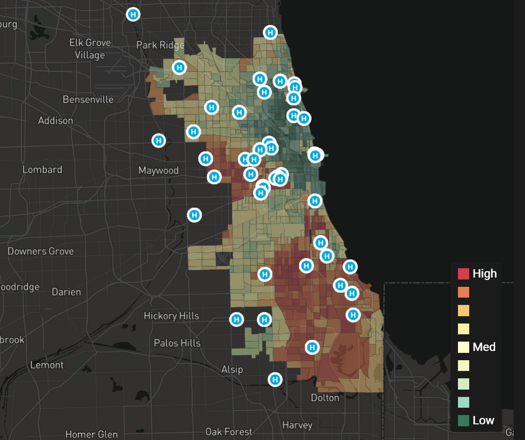
COVID-19 impact for Chicago, according to the UHVI
“In our mission to do good with data, a team of passionate RS21 data scientists and developers created this application that uncovers the most vulnerable parts of our communities,” Charles Rath, the president and CEO of RS21, stated in a press release. “When leaders in healthcare, government, business, and communities look at the impact holistically, we can make better decisions now and in the coming months.”
The UHVI map (covid.rs21.io) currently covers Albuquerque, Las Cruces, and Santa Fe, New Mexico; Aurora, Colorado Springs, and Denver, Colorado; Atlanta, Georgia; Chicago, Illinois; New Orleans, Louisiana; New York; Phoenix, Arizona; and Washington, D.C.
RS21 is based in Albuquerque and also has an office in Washington D.C. The company serves a number of state and federal agencies, including Homeland Security, the Department of Energy, and State of New Mexico.
Related Items:
Can AI Find a Cure for COVID-19?
Community Transmission: Counties Are the Front Lines in Virus Battle
Balancing Hard Data, Panic to Combat Pandemic
Sectors:
Government
Leading Solution Providers


Tabor Network
Sponsored Multimedia


Featured Events
-
AI & Big Data Expo North America 2024
 June 5 - June 6Santa Clara CA United States
 -
CDAO Canada Public Sector 2024
 June 18 - June 19
 -
AI Hardware & Edge AI Summit Europe
 June 18 - June 19London United Kingdom
 -
AI Hardware & Edge AI Summit 2024
 September 10 - September 12San Jose CA United States
 -
CDAO Government 2024
 September 18 - September 19Washington DC United States