


October 8, 2021
Only You Can Prevent… Fire Tornadoes?
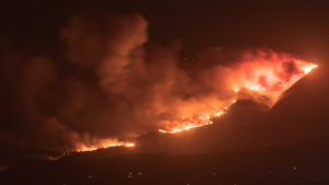
Another devastating wildfire season has shaken the western United States, causing tens of billions of dollars in damage. In recent years, terrifying weather combinations have become more prominent in these wildfires, such as fire-induced thunderstorms and tornadoes. Now, researchers at the University of Nevada, Reno (UNR) and the Desert Research Institute (DRI) have teamed to combat this fire-generated extreme weather with data analytics.
“There have been decades of success in using radar and satellite observations to issue life-saving warnings for severe weather; for fire-generated tornadic vortices and explosive storm clouds these same tools show remarkable, yet incompletely realized, potential,” explained Neil Lareau, an atmospheric scientist from UNR’s physics department and lead of the research, in an interview with UNR’s Mike Wolterbeek. “To fully realize this potential, new physical and conceptual models are needed for interpreting radar and satellite observations of the wildfire environment.”
To that end, Lareau teamed with DRI’s Meghan Collins to better understand the variables associated with these terrifying twisters. The duo launched a new citizen science project, called Ashfall Citizen Science, to help crowdsource data on the shape and size of smoke plumes and ash sighted in the wake of local wildfires.
“What we’re looking for are pictures of ash that falls throughout our region from citizen scientists,” Lareau said. “We’re looking for participation anywhere in the western states, from Idaho to Arizona. … Community science, also known as citizen science, is important to this project. Gathering this kind of data over time and in many places would be prohibitive otherwise.” Ashfall Citizen Science was launched in 2020. Since then, it’s engaged almost 20,000 people.
That ash data will be combined with data from weather radar and satellite imagery, which Lareau said will enable them to “build conceptual and physical models to facilitate life-saving warnings and enhance decision support for wildfire stakeholders using the citizen science data in conjunction with our radar observations of fire-generated tornadic vortices and wildfire plumes to interpret the wildfire environment.”
“This combination of researcher- and volunteer-driven data collection will allow us to begin to build both empirical and theoretical relationships between ash properties and radar reflectivity,” Lareau said. “This is the key to building models for prediction of these otherwise mostly unpredictable extreme and dangerous fire behaviors.”
To participate in the Ashfall Citizen Science project, sign up for the Citizen Science Tahoe program here. The web app allows users to share photos and details of their ashfall and smoke observations. “You can help track wildfire ash and help scientists demystify fire weather,” Collins said.
Applications:
Research Analytics
Sectors:
Science
Leading Solution Providers


