


January 3, 2018
Weather Data Points to Massive ‘Bomb Cyclone’ Hitting Eastern U.S.
Hurricane hunter airplanes today are flying into a building winter storm along the Eastern seaboard that meteorologists have dubbed a “bomb cyclone” due to a forecast for rapidly dropping barometric pressure.
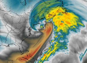
National Weather Service meteorologist Ryan Maue drew some attention when he posted a message to Twitter yesterday about the “a truly amazing extratopical ‘bomb’ cyclone” that’s predicted to blow up off the New England coast today. “It will be massive,” he wrote.
Here’s what meteorologists say is going to happen: A strong cold front dropping out of the Arctic will slam into warm, moist air sitting over the east coast. As the two air masses interact, the Earth’s spin will help create a cyclonic effect called bombogensis that will cause air pressure to quickly drop.
The National Oceanic and Atmospheric Administration (NOAA) defines bombogenesis as occurring when a mid-latitude storm that experiences at least a 24 millibar drop in air pressure within a 24-hour period. The real-world impact is a cold-core winter storm that resembles a tropical cyclone with regard to barometric pressure, wind speed, and precipitation, if not in temperature.
While it sounds exceptional, bomb cyclones are not necessarily rare. In fact, there was a bomb cyclone off the coast of the East Coast in October. However, bomb cyclones can be dangerous due to the rapid intensification they bring and the extreme weather they can deliver.
In this case, the storm that’s predicted to hit the East Coast tonight through Friday is forecast to be the most intense storm to hit the water off the coast of New England in decades, with a potential pressure drop of 46 millibars, according to Maue. That’s why the National Weather Service is flying hurricane hunter planes into the building storm: to give forecasters a better idea of where the most intense weather will hit.
The storm is also giving forecasters a chance to play with other data-generating instruments, including the new GOES-16 satellite that just settled into position over the Eastern U.S. about two weeks ago. The satellite, which now is officially called GOES-East, is giving weather forecasters “invaluable data” about extreme weather events, Secretary of Commerce Wilbur Ross said last month. It was also used to monitor the solar eclipse last August.
After days of temperatures in the single digits, Boston will bask in temps in the high 20s today. However, the bomb cyclone is forecast to bring upwards of a foot of snow to Beantown. Down south, Georgia will get a dose of freezing rain, sleet, and snow and there have even been reports of snow in Florida.
Following the bomb cyclone, temperatures along the east coast are expected to drop as the region experiences the return of another weather phenomenon: the polar vortex.
Related Items:
Predicting Hurricane Damage with Machine Learning
The Weather Company Absorbs ‘Deep Thunder’ to Bolster Modeling
Big Data Heads to Orbit with Weather Sats
All day Thursday meteorologists are going to be glued to the new GOES-East satellite watching a truly amazing extratopical “bomb” cyclone off New England coast. It will be massive — fill up entire Western Atlantic off U.S. East Coast. Pressure as low as Sandy & hurricane winds pic.twitter.com/6M4S3y75wT
— Ryan Maue | weather.us (@RyanMaue) January 2, 2018
Leading Solution Providers


