

April 21, 2022
Data Integrity Firm Highlights High-Risk Wildfire Areas in Texas
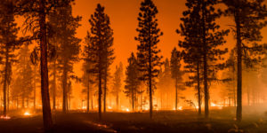
Increasingly brutal and early wildfire seasons have regularly devastated arid regions of the United States, annually burning millions of acres of land and causing tens of billions of dollars in damage. Predicting these accelerating wildfires is key to protecting the people, wildlife, and property in their paths. Now, Massachusetts-based data integrity firm Precisely is showcasing its wildfire risk assessment tool by highlighting areas in Texas that are at high risk for wildfires in the near future.
Precisely’s Wildfire Risk tool integrates a broad range of data to map risk: historic fires, historic losses, insect and disease prevalence, fire suppression measures, mitigation, ember modeling, community traits, and more. It combines these data into fire probability and severity risk measurements across all 50 states, down to the level of individual addresses.
“Our accurate risk assessment tool is based on multiple data sources that go beyond more obvious factors, such as droughts,” said Dan Adams, senior vice president of Data Strategy and Operations at Precisely. “This is especially important as landscapes and weather patterns evolve – leading low risk areas to suddenly increase in potential risk.”
Wildfires are relatively less widespread in Texas than they are in, say, California, but they still cause severe damage: tens of thousands of acres were burned in 2021, a number only projected to rise in the coming years and decades.
“Unfortunately, wildfires are increasingly becoming a real and frightening concern for many people living in high-risk areas,” Adams said. “Through our Wildfire Risk model, we’re able to help our customers make faster, data-driven decisions as they react to changing risk profiles—whether it’s an insurer better protecting communities from losses, or a city taking necessary precautions to minimize impact to citizens.
Precisely’s analysis of Texas shows, in part, that an area that had been experiencing a relative reprieve may now be due for a reprisal of strong wildfires. Bastrop County, which hosted the most destructive wildfire in Texas in recorded history (the Bastrop County Complex fire), was rated as relatively lower-risk due to the immense loss of vegetation in the wake of that fire. However, Precisely says, that vegetation has now regrown, and its risk is now rated as “high” based on the results of the Wildfire Risk model. Further, the company said, Bastrop’s relatively dense communities increase the risk of structural damage from these wildfires.
Related Items
NSF Awards $5M to AI-Powered Wildfire Management Tool
AI Startup Aims to Extinguish Wildfires
Only You Can Prevent… Fire Tornadoes?
Technologies:
Middleware
Vendors:
Precisely
Leading Solution Providers


Tabor Network
Sponsored Multimedia


Featured Events
-
Call & Contact Center Expo
 April 24 - April 25Las Vegas NV United States
 -
AI & Big Data Expo North America 2024
 June 5 - June 6Santa Clara CA United States
 -
AI Hardware & Edge AI Summit 2024
 September 10 - September 12San Jose CA United States
 -
CDAO Government 2024
 September 18 - September 19Washington DC United States