Terradepth Prepares to Fish for Subsea Big Data with Robots, Machine Learning

According to the National Oceanic and Atmospheric Administration (NOAA), more than 80% of the ocean “remains unmapped, unobserved, and unexplored” – despite constituting more than 70% of the planet’s surface. Now, a pair of Navy veterans are looking to change that with a line of autonomous robot vehicles that will plunge the ocean’s depths in search of big data for the company’s clients.
“The company really started when Joe [Wolfel] and I first got together, which was back in 2004,” said Judson Kauffman, who shares the CEO role with Wolfel, in an interview with Datanami. “We met in [Navy] SEAL training together, and ended up being assigned the same unit, and then went into combat together and became very close friends. … We cofounded a company together in 2012 – a consulting firm – which we moved to Austin and grew.”
There, they developed the idea for Terradepth, which “stemmed from some knowledge that we gained in the Navy” – really, Kauffman said, “just of how ignorant humanity is of what’s underwater, what’s in the sea.”
“It was shocking to learn how little we know, how little the U.S. Navy knew,” he continued – and the more they dug into the issue after their time in the Navy, the more surprised they were. “It seemed like a huge opportunity for someone to address.”
Kauffman said they were learning from companies like SpaceX, which were combining autonomous systems and robotics with machine learning to develop advanced systems. Then, he said, a “major breakthrough” in subsea autonomy allowed Terradepth to develop its own plan for removing humans from the equation of subsea data collection. They took their idea to one of their consulting clients, the data storage firm Seagate Technology. Seagate “loved it,” Kauffman said, and became Terradepth’s seed investor in 2018.
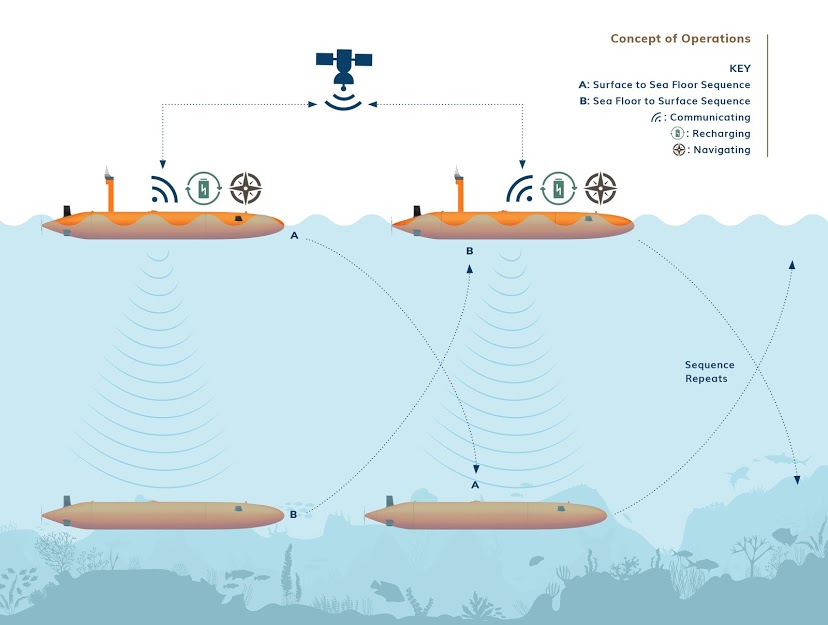
In essence, Terradepth’s plan works as follows: two (or more) identical robotic submarines, called AxVs, are launched from the shore or from the air. Over the course of several weeks (and up to 30 days), the robots – equipped with high-end sensors based on the client’s needs – alternate between subsea mapping and surfacing, with the surfaced robot both recharging and acting as a receiver connecting the subsea robot to a satellite link.
The AxVs are managed from a control center in Austin via satellite – however, they operate more or less autonomously within their defined geographic area. But, Kauffman said, if they encounter obstructions or objects of interest, they can use on-board computing and machine learning capabilities to “re-task themselves as necessary”: for instance, by detecting hydrothermal vents and routing around them. That machine learning capability is enabled by Nvidia’s PX2 platform, which was designed for autonomous cars.
Obstacle and object of interest information is relayed via satellite immediately in case the mission operators want to re-scope the mission based on that new knowledge; however, most of the data (which could climb well into the terabytes) remains onboard the AxVs due to both the high volume of the data being collected and the high cost of transmitting it via satellite.
After data collection is complete, Terradepth either sends a ship out to recover the AxVs or they bring themselves back to shore. The company then pulls the physical hard drives, uploads the contents into their cloud, completes the processing of the data, and prepares a report for the customer.
Initially, Terradepth will target “fairly near-shore regions,” Judson said – specifically, “deep-water, near-shore.” Judson floated the idea of working with an offshore wind energy client (“or even offshore telecom”). The company, he said, might contact Terradepth with a general idea of where they were looking to site a wind farm, and Terradepth, in turn, would deliver and execute on a proposal for mapping the area.
Terradepth says its high-energy sensor payload – and the resulting high-quality data – set it apart from low-energy gliders that can operate for months, but which can’t use such intensive sensors. The sensors are complemented by the machine learning capabilities, which allow the AxVs to, for instance, autonomously switch between sensors if an object of interest is detected in order to capture higher-resolution images.
That, Judson says, is the “near-term” vision – but looking ahead, the picture may be much different. “You think of a real estate company today that wants to look at what rural central Texas looks like, they can hop onto Google Earth and take a look at some of that data and make some decisions there,” he said. “We envision that sort of a relationship with subsea data stakeholders.” Eventually, he says, clients might be able to just log in and see what the subsea coast of Florida looks like without needing to contract Terradepth for a survey.
Part of this future vision also involves expanding the capabilities of the AxV itself. The prototype, they say, is capable of achieving up to 1000m depth, 1000 nautical miles of range, and 30 days of deployment time. The duo said they plan for 3000m capability soon and, eventually, 6000m – enough for an AxV to reach 98% of the ocean’s floors. (“Modifying it for depth is really a function of cost,” Wolfel said.)
Software-wise, much remains either confidential or to-be-determined, but Terradepth promises “robust connections to third-party instruments, processing software, and repositories,” and Kauffman and Wolfel said that they are already committed to strong integration with Google Cloud.
The duo expect to be soliciting commercial contracts by the spring of 2022. Starting in a few weeks, they’ll be testing their prototype in the waters of Lake Travis (just outside of Austin) and in the Gulf of Mexico. The results of those tests will inform their commercially viable beta model, the design and production of which will occupy the rest of the team’s calendar year.


