

April 23, 2020
All-Weather Image Data Put to the Test
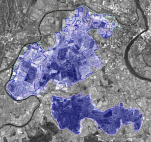
Source: European Space Agency
Mapping data collected by multi-spectral satellites is being combined with AI and computer vision algorithms to help extract ground features and building footprints. The potential applications for those data products range from disaster response and humanitarian relief efforts.
With those in mind, the maintainers of a set of commercial satellite imagery and labeled training data have released a large batch of images under an initiative dubbed Multi-Sensor All-Weather Mapping, or MSAW. All-weather refers to the use of synthetic aperture radar (SAR) along with optical imagery. Unlike electro-optical sensors, SAR is able to penetrate cloud cover to gather high-resolution imagery.
“Consequently, SAR data are particularly valuable in the quest to aid disaster response, when weather and cloud cover can obstruct traditional optical sensors,” SpaceNet announced earlier this month in releasing a MSAW image data set for the port city of Rotterdam, Netherlands.
The imagery was released in conjunction with partner Capella Space, which is developing a constellation of SAR satellites capable of image resolution as low as 0.5 meters (1.64 feet). SAR technology has long been used by NASA and the U.S. Geological Survey for detailed Earth observations. San Francisco-based Capella Space wants to launch “hourly SAR global coverage,” targeting commercial and government customers.
A satellite constellation equipped with the all-weather radar promises to deliver accurate, timely data. The multispectral imagery released by SpaceNet is among the first open data sets made available to researchers to explore the potential uses of very high spatial resolutions for applications like disaster relief.
The partners are sponsoring a challenge during which data scientists, developers and other researchers would apply AI algorithms to extract data like building footprints from the Rotterdam imagery. The MSAW data set includes 120 square kilometers of multi-spectral satellite imagery. Those data are annotated with more than 48,000 unique building footprint labels.
The combination enables the “creation and evaluation of mapping algorithms for multi-model data,” the SpaceNet maintainers said in a journal submission published in mid-April.
The researchers also developed a benchmark for extracting building footprints from SAR data.
Earlier attempts at using SAR technology for disaster management such as tracking floods have been limited to mounting all-weather radars on aircraft. The collaboration between SpaceNet and Capella Space would expand all-weather coverage, resolution and timeliness of SAR imagery via the proposed satellite constellation.
AI algorithms could then be applied to the resulting high-resolution data sets to map areas hit by natural and humanitarian disasters.
Recent items:
Why AI Is a Critical Capability for the U.S. Space Force
The Amazon is Burning, and New Analytics Tell the Story
Technologies:
Frameworks
Vendors:
Capella Space
Leading Solution Providers


Tabor Network
Sponsored Multimedia


Featured Events
-
Call & Contact Center Expo
 April 24 - April 25Las Vegas NV United States
 -
AI & Big Data Expo North America 2024
 June 5 - June 6Santa Clara CA United States
 -
AI Hardware & Edge AI Summit 2024
 September 10 - September 12San Jose CA United States
 -
CDAO Government 2024
 September 18 - September 19Washington DC United States