

February 23, 2016
CartoDB Goes ‘Deep’ with Location Intelligence

Organizations looking to utilize location intelligence may want to consider CartoDB, which today unveiled a new offering called Deep Insights that’s designed to simplify the delivery of data visualization in maps on website and mobile apps.
CartoDB is a self-service Web platform designed to allow users to extract insights from big location data. The platform–which is built on a combination of opens source tools like PostGIS, PostgreSQL, JavaScript, Ruby, and Node.js—turns layers of geospatial information into maps that users can interact with visually. No coding is required to use the service, the company says, and it can work on big data sets that include hundreds of million to billions of geospatial data points.
CartoDB enables developers to add intelligent maps to mobile apps using APIs or an SDK
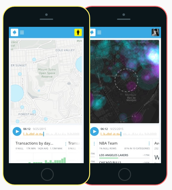
The new Deep Insights extension to the core CartoDB service (which is accessible via an API and SDK) delivers the visualization, filtering, and exploration of big location data “at unprecedented scale and scope,” the New York City-based company says. The new service lets users augment and enrich datasets with geospatial data from a variety of sources, including census information and administrative boundaries. A number of JavaScript widgets built into the platform lets users filter, pan, zoom, and narrow in on data to view trends, patterns, and anomalies that would go unnoticed using traditional reporting tools.
“The launch of Deep Insights involves a redefinition of the role of geospatial data visualization and analysis in maps, empowering the way people analyze and interact with massive amounts of existing data,” Sergio Álvarez Leiva, chief product officer for CartoDB, says in a press release. “The creation of a new visualization technology capable of identifying trends and patterns with big data, literally making the invisible visible.”
![]() CartoDB was launched four years ago by CEO Javier de la Torre, who had previously founded a Spanish company called Vizzuality that CartoDB was spun out of. CartoDB has already attracted a number of customers, including Amtrak, Axa, BBVA, Deloitte, Google Trends, National Park Service, the Royal Bank of Scotland, and Twitter. The company, which has been said to aspire to be “The Instagram of Maps,” has nabbed $23 million in Series B funding in September and recently doubled the number of employees in its Brooklyn headquarters.
CartoDB was launched four years ago by CEO Javier de la Torre, who had previously founded a Spanish company called Vizzuality that CartoDB was spun out of. CartoDB has already attracted a number of customers, including Amtrak, Axa, BBVA, Deloitte, Google Trends, National Park Service, the Royal Bank of Scotland, and Twitter. The company, which has been said to aspire to be “The Instagram of Maps,” has nabbed $23 million in Series B funding in September and recently doubled the number of employees in its Brooklyn headquarters.
Deep Insights is being launched this week at the Mobile World Congress conference that’s taking place in Barcelona, Spain. The service starts at $100 for 1GB of in-memory data on top of a base rate of $39,900 per year. The CartoDB service itself ranges in price from $149 to $825 per month
Related Items:
5 Ways Big Geospatial Data Is Driving Analytics In the Real World
Building a Better (Google) Earth
Applications:
Visualization
Vendors:
CartoDB
Leading Solution Providers


Tabor Network
Sponsored Multimedia


Featured Events
-
AI & Big Data Expo North America 2024
 June 5 - June 6Santa Clara CA United States
 -
AI Hardware & Edge AI Summit Europe
 June 18 - June 19London United Kingdom
 -
AI Hardware & Edge AI Summit 2024
 September 10 - September 12San Jose CA United States
 -
CDAO Government 2024
 September 18 - September 19Washington DC United States